Saturday 30 August 2014

And it was all going so well……………………


Written Saturday 30th August – 5.55am

The peace is wonderful; it’s so quiet apart from the sound of the river flowing over the rocks and the birds slowly starting their day.  I’m sitting in front of the camper, on the bank of the Pentecost River waiting for the sun to climb over the top of the sandstone ridge opposite me.  It’s chilly, about 10 degrees, so I’m enjoying the coffee I’ve made. Who would have thought that the week would have ended so well?
Things started to go awry the morning we packed up and left Manning Gorge.  Not is a big way, you understand, but we’d had a pretty incident free trip so far (if you don’t count the firewood falling off the roof of the car and putting a big scratch down the door of my car!)
We packed up the camper and headed out to the roadhouse where we thought we’d use the public phone there to make our Sunday morning call home.  All’s going well at home and the call mostly consisted of Tom and RaRa (his name for me) having invented conversations.  I could see the people waiting to use the phone after us rolling their eyes!!!  The 7km from the campground to the roadhouse isn’t particularly rough by standards around here, but it was enough for the chip in the windscreen that we’d got from an oncoming caravan on the bitumen near Derby to become a crack that now stretches across the passenger side.  Each day now it is slowly making its way across to see Doug.  It was to be expected I suppose, and we won’t bother replacing the windscreen till we get home, as there’s always the risk that it might happen again.
Crossing the King Edward (note the crack in the windscreen)
Our initial plan was to travel from Manning Gorge along the Gibb River Road, then take the turn off for the Mitchell Plateau and Kalumbaru.  We’d had it pretty good up until then, as parts of the Gibb had recently been graded, so the corrugations weren’t too bad.  The grader hadn’t made it to the Kalumbaru Road yet.
We turned left and almost immediately we were met with huge, rippling corrugations that you could have hidden a car in, I swear!!  We made the bone-shaking, 60km drive north towards Drysdale River Station, trying to travel at a speed that would take us over the top of the corrugations, but it was difficult to find that speed.  We passed a couple of vehicles travelling the road who were trying the nurse their cars along at about 25km/h and were dropping into every one of the corrugations as they went.  It would be a long day for them.
We arrived at Drysdale around lunchtime.  The station is a working cattle station, one of the longest family owned pastoral leases in the Kimberley, proudly working for 28 years.   They have also diversified to offer a respite for travellers on the Kalumbaru Road in the form of camping and meals.  Their Kimberley Burger is apparently famous.  We had lunch, and were disappointed to see that fuel was 10c per litre cheaper at Drysdale than it was at Mt Barnett, where we had refuelled; diesel was selling here at $2.40 per litre!
From Drysdale, we headed back out onto the Kalumbaru Road and continued north.  We were heading for the King Edward River and planned to camp there for a few nights.  It was only 103km to the turn off, but because of the state of the road, that took us over 2 hours.   We reached the campground and set up in time to go for a swim in the lovely clear water of the King Edward River and enjoy the serenity of another nearly empty campground. Well, it would have been serene if not for the dreaded gennie being run by the camper a hundred or so metres from us.  Enough said, but we did go and ask them to turn if off about 7.30pm.
The falls on the King Edward near our campsite
The next day (Monday) was going to be a big one, and we were up and getting organised early.  We had chosen to drive up to the Mitchell Plateau and the falls and back in a day rather than camp up there, fearing the constant helicopters taking off and landing all day at the campground would be less than peaceful.  It meant that we wouldn’t have time to explore further and take in Surveyor’s Pool and Point Warender, but there would always be next time.
The road from King Edward to the campground at Mitchell Falls was 75km, and we fully expected it to be a nightmare, so had allowed plenty of time. As it was, the road had been recently graded, and although still rocky, it wasn’t as bad as we expected.  It was a good thing that we’d allowed plenty of time, as about half way up we heard a loud noise coming from the roof rack.  One of the brackets had come loose a few weeks earlier, so we thought that something similar had happened again.  Doug got out and tightened everything, and we set off again – noise still there.  It turned out that one of the brackets had snapped in half.  There was nothing that could be done at the side of the road, so we nursed the car the rest of the way to the campground and decided we’d tackle it when we got back from our day exploring.
The Mitchell Falls is one of the images of the Kimberley that everyone knows, the vivid green water flowing down through the series of four waterfalls into the valley below.  But what they don’t tell you is how beautiful the whole plateau is.  It’s like being in another world.  During the drive up we noticed the vegetation changing, the eucalypt woodland was now dominated by thousands of Livingston palms; you wouldn’t be surprised to see dinosaurs in an area like this. And every so often the road got close enough to the edge of the plateau to reveal beautiful views that went on forever.
Big Mertons Falls
The hike into the falls took us about two hours, with a bit of rock scrambling and a lot of stopping to take in the scenery or look under ledges for hidden Aboriginal art.  We passed Little Mertens Falls on the way, which had not long stopped flowing, and further up the track, came across Big Mertens Falls (now called Mertens Gorge).  It was still only just flowing, but you got the feel of the immensity of the water in the wet.  We crossed the river and looked over the edge into the gorge below.  It was here too that we met up with the first tour group of our trip.  We had expected the APT crowds to be everywhere, but had so far managed to avoid them, but our luck had come to an end.  I’ve got to the give oldies their due though, it was no mean feat for them to get up here, some of them with walking sticks and all.  I would like to know what kind of waivers they sign when they book for these kind of trips.  One of them could easily have done a hip!!
Rock art near our campsite thought to be over 17000 years old


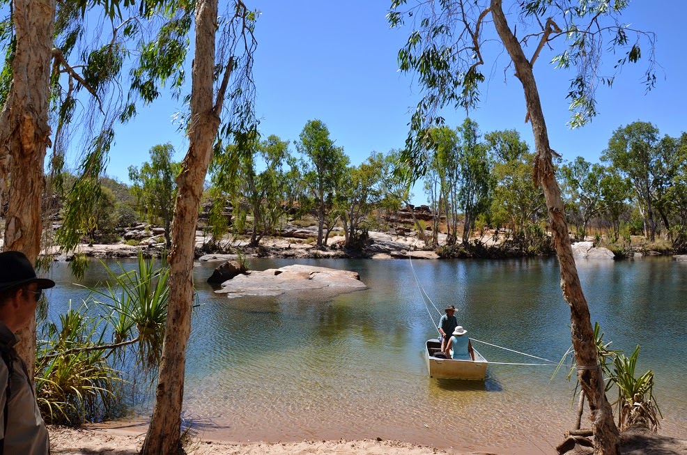
Not far from Big Mertens we emerged at the top of the Mitchell Falls.  We had to negotiate crossing the Mitchell River, hopping across rocks (or in my case, being dragged by Doug), to get round to see the falls in all their glory. 
Mitchell Falls
We spent a couple of hours at the top of the falls.  We had some lunch, did some exploring and had 
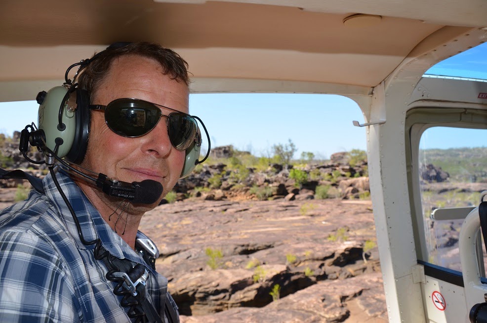
a cooling dip in the water before getting picked up by our chauffeur, Phillippe, who flew us out and over the falls, and back down to our car.  What a way to end a great day.

Post-flight hair style

Mitchell Falls from the air
Back down and now to address the problem with the roof rack.  It was going to be a simple fix.  Doug would just replace the broken front bracket with one of the middle brackets, and that should be enough until we can get it fixed, possibly in Kunnanurra in a couple of weeks.  Should take about half an hour and then we’d be right for the two hour trip back to camp, in time for a swim.
The problem was, though, that when he took off the middle bracket to move it to the front, it was broken too.  And then he thought he’d take the middle bracket off the other side and use that – you guessed it – broken too.  So here we were, two hours from our camper, with three out of six mounts for the roof rack broken. 
Hindsight is a wonderful thing, isn’t it?  When I looked at the broken brackets, I wasn’t surprised they had broken.  They were made of woefully thin material that hadn’t stood up to the stresses of the roads we’d travelled.  The rack was fine, but the mounts were only suitable for dodging round town.  It probably had been coming over time, but the roads north from the Gibb River Road had sealed the deal.  But hindsight doesn’t help when you’re stuck.
I had had visions of us leaving the rack and its contents with the ranger and coming back the next day with the trailer, and somehow trying to get everything onto the roof of the trailer, then taking it all off again every time we set up camp.  But I have a very clever husband, and we were aided by a very helpful Ranger (thanks Ranger John).  The Ranger Station had a scrap yard and maintenance shed, which he said we were welcome to.  So over the next two hours, we scrounged in the scrap pile and found enough angle iron for Doug to make six new brackets for the rack.  We fixed it enough for us to make a slow journey back to our camp, and even got there in time to have a very quick swim before dark.  And a well-earned beer.

The next morning was spent fitting all of the newly made brackets (which are probably stronger than the ones that were on it).  Running repairs were also made on the strap holding the wheelie bag on, as it had fallen victim to the roads too.  I took this chance to give the car a bit of a clean out and do a bit of washing.
Although the roof rack was now sound, we made the hard decision that, rather than continue our trip further north to the Aboriginal community of Kalumbaru, where we’d planned to spend a few days, it might be a better idea to head back south.  Just in case we had further problems with it.  So we had another swim in our lovely pool in the Kind Edward River, and then packed up the camper and headed back down to Drysdale.
The grader had been making his way south, and the trip back, for the most part, was far better than the way up.  We arrived late in the afternoon, set up the camper, had a wonderful shower, and headed over to the homestead for a Kimberley Burger.  It was a great night, and a bit of a relief that the roof rack had held up so far.  It was also nice to catch up again with Ranger John, who was down that way to do some work.  We were able to buy him a drink or two by way of thanks and, after his twenty years of working there we learned a lot about life on the Plateau.
We said goodbye to Drysdale the next morning.  This next stage travelling back to the Gibb River Road, where the grader hadn’t reached would certainly test the repairs on the roof rack.  But it all seemed to be holding well, and we reached Ellenbrae Station for morning tea.  Ellenbrae had been a planned stop for the night, but since we had changed plans, and were way ahead of ourselves, we kept going.  After enjoying their famous scones, jam and cream of course.

As we travelled along the road, heading for Home Valley, our next intended stop, we noticed another grader driver busy doing his thing.  Great, we thought!!  What we didn’t notice was the large rock he’d graded into the centre of the road, amongst the pile of dust.  It hit the underside of the car with a loud bang, and we pulled over to see what the damage was.  Thankfully the car had underbody protection plates, as there was a large dent in one of them, and it had broken it off the chassis.  So we now had developed a very loud rattle when the revs were low to go with our dodgy roof rack!  Nothing for it but to head on to Home Valley, where Doug said he could fix it, but everyone will definitely hear us coming.
Not much further we came across a rental car at the side of road, up on a jack, with both passenger-side wheels damaged and a big dent in the side of the vehicle.  A nice French woman was sitting in the little shade there was waiting for her husband to come back.  Someone had given him a lift to try and organise repairs.  It seems they had found similar rocks to us while following the grader.  After making sure she had enough food and water with her, we left her sitting there, hoping that she would be alright.  Home Valley was only 50km or so away, and there was a reasonable amount of passing traffic on the road. 
Home Valley is owned by the Indigenous Land Corporation, and runs a training academy for indigenous people in the area, offering apprenticeships and training.  I was really looking forward to spending time there, but Home Valley is probably the biggest disappointment I’ve had so far. 
We arrived early afternoon, and the first impression you get is one of a very touristy resort, with a big pool, children’s playground (a la McDonalds) and huge restaurant/bar area.  The campground near the pool was small, and reasonably busy (remember we’d had a lot of places almost to ourselves recently, so anything would seem busy).  We had heard that they also offered a bush campground further out on the banks of the Pentecost River, so we decided to check that out.
After a 4km drive, we reached the bush camp, which was weedy, open and exposed, and again, reasonably busy.  It wasn’t much for the $37 per night they wanted.  That, together with the fact that there was nothing you could access on the property yourselves, without signing up and paying for a tour.  You could do a couple of self-guided walks but walking wouldn’t get you very far to see what the property had to offer.
We sat and thought for a while, and watched another half dozen vehicles arrive and look for camping spots.  El Questro was only another 50km further down the road, so we decided to make a break for it, and jump further ahead of our planned itinerary.
The famous Pentecost crossing - not much water at this time of year unfortunately
 We arrived at the famous gateway to El Questro on Wednesday afternoon, and secured ourselves a private riverside campsite, well away from the station township.  Yes, township – that gives you some idea of the size of the place, and the slickness of how it’s run.  We originally booked in for four nights, but have extended it now to six. 
Turn off to El Questro
 Now this post is more than long enough, so I’ll leave telling you about El Questro till the next one.  The sun is up now and the day is warming up.  Doug’s up and has made me my toast, so we’re all set to take on the day. 

Thursday 28 August 2014

Gorgeous gorges, wondrous waterfalls, green ants and dickey knees!!


Written – Saturday 23 August 2014.

Week one along the Gibb River Road has come to an end.  I said to Doug over our late afternoon wine today, that we’ve done so much, but travelled so short a distance that’s it’s hard to believe a week has gone by.
 
We left Derby early last Saturday, and the town was quiet as we headed out to start the Gibb River Road – one of Australia’s iconic touring destinations, still with a bit of adventure mixed in with it.
Our travelling distances for the duration of the Gibb will be shorter than we’re used to, but with lots packed in.  We travelled the 150 or so kilometres to Windjana Gorge, arrived at the campsite and quickly set up the camper.  It was going to be a big day.
After a cuppa, we headed off on the walk into the gorge.  It had been almost two weeks since we’d donned a pair of boots, so it was a bit strange to have them on again after slopping around in thongs, but the walk into Windjana required it.  Along the way, we spotted a friendly tree snake who slithered across our path.  He was still there, worrying passing French tourists when we returned 2 hours later.

 
Windjana Gorge the most accessible gorge of the Kimberley, being only a short distance from Derby, and most of that on sealed road.  Because of this, we were expecting throngs of campers, however, the campground wasn’t as busy as we were expecting, and neither was the gorge.  Although there were a few tourists around, not many of them chose to do the longer walk to the end of the gorge.  We enjoyed the views of the towering cliffs that surrounded us as we clambered up and down river banks, and scrambled over trees.  Part of the attraction of Windjana is the freshwater crocodiles.  Hundreds of them sun themselves on the banks of the river each day and seem oblivious to the hoardes of tourists that try and get close enough to take their photo.  Freshies are harmless creatures who will leave you alone of you leave them alone, so that’s exactly what we did.
 
We returned to camp and grabbed a quick lunch, and then headed off the 30km or so, down the road to Tunnel Creek.  Tunnel Creek is part of the same Devonian reef that forms Windjana Gorge (and further on Geikie Gorge), but at Tunnel Creek, the river has cut a tunnel through the range, and you are able to walk the 800m or so through it, wading through thigh-high water in the complete darkness, with only your torch to find your way.  It was a fantastic experience – we set off armed with head-lamps and torches, with cameras held high and with no small amount of uncertainty.
 
We were thankful that about half way along the tunnel, sometime thousands of years ago, the roof of the tunnel had caved in and sunlight came streaming in and lit up a beautiful chamber.  We were lucky to find that the sun, at that particular time, came in at the right angle, and lit up the surrounding rock faces beautifully.  We then stepped back into the darkness to make our way to the end of the tunnel, emerging into the most gorgeous little valley, where the river trickled, the trees offered dappled shade and our eyes adjusted back to the daylight.  We sat here, all alone and just soaked in the beauty.
 
Back into the darkness, as we had to re-trace our steps back to the beginning.  We met an English family on the way back who were struggling in the darkness with only one small torch between three of them.  It was hard to negotiate the deeper parts of the water when you can’t see where the rocks are, and the mood wasn’t good.  Thankfully there was only about 100m to go, but it was probably the hardest, with slippery rocks to climb over.  Poor mum managed to slip and fall just as she was leaving the cave, and land back in the water, ensuring that everyone around knew she had a very wet backside!  While Doug and her husband tried to get her up and on her way again (hopefully without any injuries) her son thought it was hilarious and didn’t offer much sympathy.  I wouldn’t like to be him when they got back in the car!!!
The next day we packed up camp and moved on to Bell Gorge.  That’s the thing about this part of the Kimberly, everywhere you look there are gorges, and waterfalls (although not so many waterfalls at this time of year).  Bell Gorge is renowned as being the most beautiful of all the Kimberley gorges, but I don’t agree – there are just too many to choose from.  At this stage we were still excited about what was to come.  We arrived at the Silent Grove campground and set up the camper, and couldn’t quite accept that we’d got the right place.  From what we’d heard, Silent Grove was meant to be a pretty busy campsite, given the popularity of Bell Gorge, but there was only one other campsite set up.  No one else!!!
 
We spent that afternoon exploring Bell Gorge and swimming in the beautiful pool at the top of the falls.  The climb down into the gorge was lovely, and when we came out into this oasis at the top of the falls, it took our breath away.  We could have climbed down to the pool at the bottom of the falls, but there was already a few people down there, and to be honest (and taking dickey knees into account), we were happy to have the lovely pools at the top all to ourselves.
 
After leaving Bell Gorge we moved on and took the rough 90km side road to Mornington Wilderness Sanctuary.  Mornington is run by the Australian Wilderness Conservancy (AWC), an organisation which buys up strategic properties Australia-wide with an aim to restore the habitat for all living creatures within its boundaries.   With this in mind, it is run more as a sanctuary that devotes a small part of its work to tourism.  Numbers are limited (only 25 vehicles permitted at one time) and there are strict regulations as to what you can and can’t do whilst on Mornington.  We spent three glorious days here, exploring the gorges, taking the walking trails and swimming in the waterholes. 
 
The highlight of our stay was our canoe hire.  We had a two man canoe to explore Dimond Gorge on the Fitzroy River, and, like Bell Gorge, we had it all to ourselves.  We had a wonderful day paddling the length of the gorge, stopping on a sandy beach for lunch and a swim and then paddling back in the afternoon.  We explored the caves and rocky inlets along the way, and looked for crocs, but unfortunately didn’t spot any.

 
The 180km round trip to Mornington was worth the corrugated roads, and we loved out time there.  After that we moved not very far further down the Gibb to take the turnoff to Charnley River Station.  This is another property managed by the AWC, although only recently taken over.  It used to be a working cattle station, but now they are in the process of de-stocking it, and returning the habitat to what it was previously.  Charnley is approximately 330,000ha, and the campground is managed by a lovely couple (Lorrie and Chicko) who made us feel very welcome.  We camped under the shade of a wonderful old tree and spent two days exploring the property.  The first day we spent up at Donkey Pools, as series of waterholes, the third still had water we could swim in and the rocky outcrops overlooking the pools had some Aboriginal art if you looked closely enough.
 
After a night in the campground (a huge area in which we were only one of three campers), we spent a big day exploring the rest of the property open to the public.  We travelled up to Grevillea Gorge in the morning, and found it mainly dry at this late stage in the dry season.  We were told of more Aboriginal art if you climbed down far enough into the gorge, but Lorrie advised that people with dickey knees of hips should maybe give it a miss.  With this in mind, I sat on a rock in the shade while Doug continued down the dry river bed.  After a while he came back, defeated.  He said it would involve a climb down a sheer rock face, and since he had the keys to the car in his back pocket, he thought he should come back….. just in case.  I said “if Pete Copeland had been here, he would have been off down there in a shot”.  Doug said, “If Pete had been here, I would have gone with him!!!”  You could have joined me on the rock in the shade, Gill!
 
Because it was late in the season and quiet, Lorrie and Chicko offered us another night at Charnley free-of-charge, and we had every intention of taking them up on their offer and having a rest day the next day.  But when we got up on the Saturday morning, we discovered our camper was directly in the line of the path of a hoard of green ants travelling from one tree to another.  Green ants are a wonder to behold……….from a distance.  They travel huge distances in a line, and carry food and plant material back to their nest.  They also drop on you from above, or climb up your leg and bite!!! 
We did the “ant dance” for a good hour, trying to brush them off the camper, the towels, the shoes and ourselves before deciding the pack up.  We had originally thought we could move the camper to another part of the campground, away from the ants, but if we had to pack it up to move, we might as well move on.
So we regretfully packed up and said goodbye to Lorrie and Chicko and headed off back to the Gibb to continue our journey east.
 
Back on track we headed for Mt Barnett Roadhouse, which is the gateway to Manning Gorge.  Mt Barnett is one of the few places along the Gibb River Road that you can get fuel and supplies so we stopped to restock on a few things.  I had to keep reminding myself of where we were, and the remoteness of trying to get supplies out here, because the prices they were charging were unbelievable.  After more than a week since leaving Derby, we were glad to be able to get some fruit and vegies, but they came at a cost.  I guess everything does up here.
After gathering supplies, we travelled down to the campsite outside Manning Gorge and set up the camper.  The plan was to hike into the gorge in the afternoon, spend some time there and hike back out in time for tea!!  Manning Gorge is another of the “must-sees” along the Gibb River Road, so we expected the campsite to the busy.  Again, and thanks to travelling later in the season, it was pretty quiet.
The track into the gorge is about 3km each way, and to commence you have to cross the Manning River.  Thankfully now, they have a dingy on an endless rope that you can travel across on, rather than having to swim across. 
 
Now when they say that a track is 3km each way that didn’t seem to be an issue, but if I’d known that 3km (each way) would be pretty much climbing up and down rock faces, I may have thought twice about whether it was a good idea.  But no such warning exists at the start of the track – just “a reasonable level of fitness is required”!!!
Once again, dickey knees gave me a bit of a hard time, but there was no point in giving up.  After over an hour of scrambling up and down rocks (with a lot of help from my lovely husband) we made it the gorge – and lo and behold, again we had it to ourselves!  The scrambling had been worth it.   We sat and had lunch, and enjoyed the wonderful clear water of the river before I faced the scramble out again.  This was by far the hardest walk I’ve had to do, and by the time we got back to the dinghy to cross the river back to camp, my dickey knees were shaking!
 
I think the thing that we’ve been so surprised at after our first days on the Gibb is how quiet it is.  We fully expected most places we went to be over-run with other tourists, but it hasn’t been.  Sometimes there’s been a few other campers, but a lot of the time, we’ve been on our own – something we weren’t expecting at all, but something we’ve absolutely relished.  It’s not everyone can say that they’ve paddled Dimond Gorge all to themselves, or skinny-dipped at Dillie Gorge cause there was no-one there.  Later in the dry season means that some of the rivers, falls and waterholes are drying up, but not all….and if it means there’s less tourists, then we’re happy.
 
Let’s see what we find next!
 

Saturday 16 August 2014

Now, have I mentioned how much I hate generators????

I thought I would spend this post describing the wonders of the Dampier Peninsula and all it has to offer – the pristine white beaches, the clear water.  Well, to a certain extent, probably the most part, that’s so true.  But I just have to get a moan off my chest, and then I can get to all the wonderful stuff.

To set the scene…….. we left Broome on the morning of my birthday.  We hit the road early and fuelled up at the servo and filled the water tanks, and before we left, we spent some time wandering round the weekly market at the Courthouse Gardens.  Very arty-crafty, but fun. 

The journey to Middle Lagoon on the Dampier Peninsula was on a rough, unsealed, corrugated road that was the worst we have travelled on so far.  You spend the time trying to move from side to side on the road, trying to find a place that the corrugations weren’t too bad, but without success, because there just wasn’t anywhere where the corrugations weren’t too bad!!!

Corrugations on the Cape Leveque Road
We travelled the 2 ½ hours to Middle Lagoon without incident and arrived at the small campsite run by a local Aboriginal family.  It is a wonderful experience to be able to share their backyard and camp on the exceptional coastline that makes up this area.  When we arrived we were speaking to Ernie, one of the family, and we mentioned that someone who we’d been speaking to in Broome suggested we ask for a campsite on the ridge.  Although he had ear-marked us for another site, he said we could go and check out the available a space on the ridge, and let him know what we thought.  His parting words were – “I know what you’ll choose”.  And he was right.  Although the camping on the ridge had wonderful views out over the bay, you were very exposed to the elements – no shade from the hot sun, and wind right off the ocean.  We went with what Ernie thought, and found out perfect campsite under a tree, just a bit off the ridge, sheltered and still with wonderful views (albeit with a few enormous caravans in the way).

Our campsite at Middle Lagoon
Now comes to my moan.
What is it with grey nomads in caravans with enormous power requirements that necessitate them having to immediately hook up generators as soon as waking, until well past most of us have gone to sleep?
Doug says I’m dwelling…… and perhaps I am, but humour me.  Imagine the scene – perfect day spent enjoying the pristine environment, walking on beaches, swimming in the clear water – you know the thing.  After a swim, we’d have a lovely cool shower, and all clean and refreshed, we’d sit down with a wine to enjoy the sun going down over the ocean.  At this point, “Graham” the Grey Nomad feels the need to start his generator, to charge the batteries in his enormous “off-road” caravan.  Now rather than disturb his perfect sunset, he takes his generator about 50 metres of so behind his caravan (50 metres towards us!!!) and starts it up.  Peace is shattered!!!!  He didn’t seem to understand what I was going on about as I loudly protested about how it was so good of him to share his “toy” with the rest of us.   As I said over and over again (as Doug pointed out), we spent the time and money setting ourselves up to be able to power what we need by solar or when we’re driving – if we can’t power it, we don’t have it!  Why you need a TV, satellite dish, microwave, electric kettle etc out here I don’t know!
Ok – on to the more important details of what a wonderful place the Dampier Peninsula is.
We spent two wonderful days at Middle Lagoon.  There’s nothing there.  Just the coastline.  We walked far down to the creek one afternoon, and when it got too hot on the return walk, we’d just have a swim in the crocodile-safe bay.  I had another experience swimming with the fishes – as we took a break and headed for the water while walking back.  As we waded through the low-tide water Doug spotted a dolphin fin about 10 metres from where we were swimming, and as I moved further into the water, what I thought was a rock, about 2 metres from me began to swim away.  I’m still not sure what it was, as I was only able to see the shadow, but my guess is a ray – and the large school of small fish that were disturbed by it thought so too.  A bit unnerving to say the least as they all swam towards me to get away from it.
Sunrise walk
 
Arty-farty shot
Our time at Middle Lagoon came to an end, and we thought it couldn’t get any better.  But we were to discover that there is so many lovely little places on the Dampier Peninsula that you could spend a couple of weeks just meandering up and exploring.  One of these places was Whalesong.  Not far from Middle Lagoon, just a bit further round Pender Bay, we discovered a tiny community where they offer very limited camping, and the best little café you would never expect to find.  This place is 35km off the Cape Leveque Road (which itself is not busy) so I’m not sure how much passing trade they get, but they grow all their own vegetables, and the food they offer is all homemade and wonderful, as well as the best organic coffee served on a deck overlooking the bay.  It was a delight to spend a morning there.
From there we travelled further up the Cape Leveque Road until we reached Kooljaman.  Above everything else, Cape Leveque is famous for its beaches, and justifiably so.  Kilometres and kilometres of powdery white sand, interspersed with rocky sections and dotted with treasures the tide left behind.  We watched the sun rise out of the ocean from our bed, and on the other side of the tip, we watched it melt back into the ocean at the end of the day.
We rented a beach shelter, camped right on the beach, with a fire pit and a fresh-water shower.  What more did we need?  We spent three glorious days in this wonderful place.
Our beach shelter at Kooljaman
 
Sunrise at low tide on our beach
 
Ahhhh
Time was spent swimming, walking, fishing and exploring the rest of the tip of the Cape.  One afternoon I was determined that the fishing rod I had specifically bought for the trip (thanks again David Wood) was not going to go to waste, so I jumped on a fishing charter boat leaving from the next beach.  What great fun!!!  I spent the afternoon learning all sorts of tricks and tips from an old master, and had the buzz of catching three fish!!!  Honestly… they were “this big”!!! (Holds hands far apart).  But really, they were too small to land, so had to be released.  Fortunately, one successful man on the boat took pity on me, and rather than us have another night of spaghetti bolognaise, he donated a nice Golden Trevally to me to take home for dinner.  Yum!! (sorry, no photos, I was busy at the business end of the rod!!!)
 
We spent a day out and about on the Peninsula, travelling first to the Aboriginal community of Lombadina, where Trapist Monks set up a mission in 1934 and a thriving community now is a model for other indigenous groups in the area.  They have a bakery there and we were able to buy a loaf of their wonderful bread before setting off for Ardyaloon, another lovely little Aboriginal village.  They have established their own hatchery there for trochus shells and other marine life and we were able to look around and learn about how these proud salt-water people live at one with the land and sea.  I got some really good tips for cooking the next fish I catch!!!
The church at Lombadina
 
Architectural wonder made of mangrove wood and paperbark
 
A fabulous mangrove tree at Lombadina
We called into the Cygnet Bay Pearl Farm on the way back, and learned about the Brown family and how they have been farming in the area since the 40’s.  From the days of wooden pearl luggers and huge, heavy diving gear, to the slick operation they now have, where they harvest 20,000 farmed pearls a year.  In the gallery I was drawn to one or two of their beautiful creations, but with price tags of over $20,000, I’m afraid they had to be left for the next time.  Their farm also includes a wicked restaurant, where we enjoyed a great lunch, before rolling back to the beach shelter for an afternoon nap.
The beautiful but croc infested Cygnet Bay
Our time at our beach shelter all too soon came to an end, and we left Kooljaman yesterday morning.  We called in to another lovely Aboriginal community, Beagle Bay, on the way down south again.  Here they have the most beautiful church, built by the local Aboriginals and the Catholic brothers at the time.  The entire interior is decorated in mother of pearl, from locally harvested shells.  The work and the time must have been amazing.  The church is not a museum piece, but still a lively and essential part of this vibrant community.  We really enjoyed being able to look around it.
Beagle Bay church
 
The pearl encrusted alter
 
 
After leaving Beagle Bay, we took a side track, heading down a “short cut” which would bring us out on the highway on the way to Derby.  Although this short cut probably saved us about 90km, it didn’t save us much time.  The road at the start was narrow and overgrown, and in a lot of parts, the track was deep, soft sand.  But it was so much fun, and so great to avoid the corrugated main road back down to the highway.  We had a ball.
Our short cut track
 
The sign posting was hard to miss!!
We arrived in Derby and have set ourselves up at the caravan park in town and have spent today shopping, washing, catching up on chores and seeing the odd sight.  The restrictions on the sale of alcohol in the region meant that we had to make several trips to the bottle shop to stock up for the next part of our journey – I’m sure the guy behind the counter thought we must have a problem!!
The prison boab tree at Derby - thought to be about 1200 years old
Tomorrow we head out to start our journey across the Gibb River Road.  Although this road is only about 650km, we plan to spend about 4 weeks travelling along it (and its various side tracks).  There’s so much to see and we’re really looking forward to it.
Mobile reception will be patchy over the next few weeks so my next entry might not be for a while.  But I’ll catch you all up eventually.


Friday 8 August 2014

Rotors, outboards and wings - and that’s all before breakfast!!!!

Well, Karen Nankivell – I can’t find the words to thank you enough!  Your suggestion of spending the night at the Horizontal Waterfalls was an absolutely perfect way to celebrate a milestone birthday.  I still have the smile on my face four days later.

The day we left Fitzroy Crossing to travel through to Derby to catch our flight was just like any other morning.  We got up, had coffee and breakfast and set about a relaxed pack up.  But after spending time in a few different caravan parks (not our thing usually) on this trip, I’ve decided we’ve got to get into the way of things.  The correct attack plan is to be awake before daylight, and dressed, fed, packed up and be ready to hit the road about 6.30am!!  Honestly, I’m not sure where they go to at that time of the day, but by 7.30am, the caravan park was nearly empty and we were sitting there, drinking our coffee, wondering what we were doing wrong.

So… we were on the road by 9.30am and headed the two hundred and something kilometres to Derby.  We got there around lunch time, enjoyed a counter meal in the pub and then went to the arranged place to leave our camper and car for the night.  Making sure it was all tucked up nicely, we waited to be picked up for our big adventure.
The booking instructions had said that we were to take as little luggage as possible (just a small backpack – limit 5kg) and it was to include a change of clothes, bathers and towel, necessary toiletries and camera, and it was BYO alcohol.  So, needless to say, ours were a “tad” overweight, by the time we got the essentials in.  We were a bit relieved to find that the most of the other people waiting to get collected at the same spot were thinking the same thing - “I hope they don’t weigh my bag!!!”.  Never mind, it will weigh less on the return flight.
Our carriage awaits
We were collected on time, and taken to the Derby Airport.  I use the term “airport” loosely, but, planes did land there.  Our seaplanes arrived and we were carefully seated on the plane so as to balance out body weights to make for a comfortable flight.  The pilot did it all by eye – brave soul.   The flight took about 30 minutes to arrive in Talbot Bay, in the very north of the Kimberley region, an area that can only be reached by plane or boat.  The landing on water was a new one for me, but it was effortless, and we sailed to a stop by the pontoon, and quickly got out and collected our bags.  In the middle of this beautiful environment, away from any other living souls, we had this wonderful place to ourselves. 
First sight of the falls

The accommodation was made up of a houseboat, several pontoons and jetties, and several jet boats.  It made for a great space, which we could move around and spend time in as we saw fit.  There were bar areas, 10 cabins, a dining area, swimming cage, and helicopter pad.

Our home for the night
We were whisked away pretty quickly when we first arrived, to board a jet boat, to speed out to see what we’d came for – the Horizontal Falls.  The tide was on the way in, and we had to make the most of it before dark.  The jet boats flew around the bends to the falls, and then for about 20 minutes or so, we had fun riding up and down the water as we moved between the bays.
 
The falls are created by the huge tides of the Kimberley, being forced through a series of gaps in the McLarty Range.  The gaps are quite small, one being 20 metres across and the second being only 7.5 metres.  The rate of flow of the water can’t go through the small openings fast enough, therefore it builds up higher on one side of the gap, making for a waterfall effect – only horizontally!  Essentially, we’re travelling uphill and downhill on water.
Going uphill on water
After returning to the houseboat, we spent the rest of the evening relaxing, cruising round the beautiful bays of the area, swimming in the shark cage with a few visiting Tawny Nurse sharks and enjoying a wonderful dinner on the top deck as we watched the sun go down, enjoying the company of our fellow passengers.
Swimming with the fishes again.
Some friends coming to join us for dinner
 
 
Our cabin had a huge picture window, and we were able to lie in bed and watch the stars as we fell asleep, and then the wonderful colours of the sky in the morning, as the sun rose.  Although it was a bit disconcerting to have a different view of the surrounding cliffs than when we went to bed.  The pontoons swing on their moorings as the tide comes and goes.  No, we hadn't broken free and were drifting towards the rocks!!!
We were up just before 6am, as we had decided to take up the opportunity of having a sunrise helicopter flight round the bays and across the falls before breakfast.  Neither of us had been in a helicopter before, and the experience was made all the better as Trent, our pilot, had taken the doors off for the flight. 

Taking off in the morning

I was still hanging on at this stage.
 
I started the flight clinging on to the side and front bars, trying to take photos one-handed, but after a couple of minutes, I was like “whoo-hoo!!!”  It was the most wonderful experience – without doubt!!  I couldn’t keep the smile off my face for hours afterwards, and my hair took all day to recover too!!
Early morning view of the falls

 
Then after that, just to add to the morning, we headed back out on the jet boats, as the tide had turned and was on the way out again.  This time it was higher, and we had another fun half hour playing in the swirling water.  The colours of the early morning sun on the gorge walls was just beautiful.
8 knots to maintain our position - amazing
 
We had a quick bite of breakfast and gathered our gear together, and sadly, all too soon, the planes arrived to take us back to Derby.  The flight back to Derby took the scenic route, flying out over the Buccaneer Archipelago, a series of over a thousand small islands off the north-west coast of Western Australia.  It is absolutely beautiful, remote country.

Coming to take us home (sad face). 
 

The Buccaneer Archipelgo

The wilds of the Kimberley burning.

We landed in Derby around 8.30am on Monday morning and sat there wondering what we’d do for the rest of the day.  Having packed so much excitement into the first couple of hours, anything else would be sure to be a let-down.  I thought I’d have to have a nanny-nap to get over the adrenalin-rush of the first hours of the day!
But back to reality!  We collected the car and camper from where it had been stored, grabbed a coffee in town, and then headed out the road towards our next destination – Broome.
It only took a couple of hours and we had arrived at our campsite for the next few days.  Again, after a recommendation from Karen, we chose to stay at the Broome Bird Observatory.  This world renowned bird wonderland sits on the shores of Roebuck Bay, a short distance out of Broome, and offers limited camping in wonderfully quiet surroundings.  I’m not sure if any of you have visited Broome in peak season, but it’s a bit of a bun-fight and the caravan parks (the only available camping in town) are chock-a-block, with queues forming outside the gates every day for the few available vacant sites.  This really wasn’t us at all, so the peace and serenity of the BBO was worth the 20km drive into town when we needed to visit.  It does, however, have its fair share of “birders” staying here; a strange type of folk who take their birds very seriously and can’t quite understand why we’re here and we don’t!!!
This week has been spent so far, doing a few touristy things, visiting the sights in town, having a beer at Matso’s, driving up and taking in Cable Beach, walking out to Gantheaume Point and driving up to Willie Creek Pearl Farm and the points north of Broome on the Dampier Peninsula.  The weather has been picture perfect every day, 30 degrees or so and the nights have been cool enough to sleep well.
Gantheaume Point

 
Today, we’ve got the car booked in for an oil change at a local garage.  The plan was always for Doug to do it himself on the way round, but finding somewhere where he could do it (certainly not in the pristine environment of the BBO), and then where to dispose of the waste oil became too hard, so it’s off to visit the mechanic first thing this morning.  I am currently sitting in the laundrette getting the washing done before we head back up Cable Beach to spend our last afternoon in Broome sitting, lunching, swimming and reading on the white sand.
Cable Beach - a cliché, but still so beautiful

White sand and clear water

Just drive till you find a bit to yourself.

Dampier Peninsula and Cape Leveque next!!!  It just keeps getting better.